Route details
Distance: 11.7 kilometres
Time: 2:38
Ascent: 282 metres
Speed: 4.4 kilometres per hour
Our experience
Our afternoon’s hike was the GR13.10 – Monchique to Alferce – 11.7 km, which meanders through the Monchique valley along historic footpaths before climbing (and descending) steeply to return to Alferce.

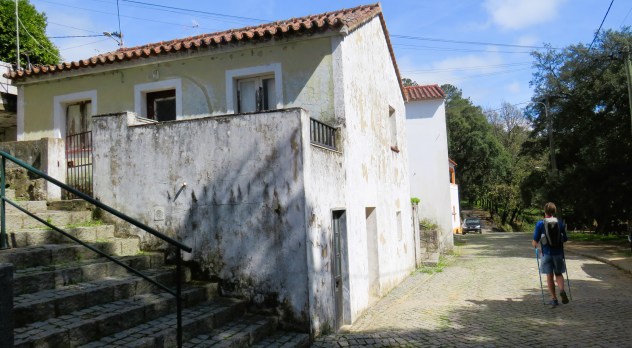
Nothing revives the spirits like a beer in the sun; however, we couldn’t linger outside Velochique for too long as fatigue was rapidly setting in. Forsaking food until we had a few afternoon miles under our belts (beer stops are bad enough!), we trundled back down the steps we’d climbed half an hour earlier and retraced our steps through Monchique’s municipal park. We crossed the site of the monthly market to join a wide wooded path lined with cork oaks and running parallel to the Ribeira de Monchique in the valley below. This is the historic route through the Monchique valley that was once followed by those walking between the town and nearby Alferce. Nowadays, of course, there is a road between the two locations.

We managed to miss a magnolia tree with an information plaque, but I put that down to our overall delight at finding ourselves in such a gorgeous, previously undiscovered (by us at least) landscape. I later learned (from an article in Portugal Resident) that Monchique was once home to the oldest magnolia tree in Europe. That particular tree was growing in woodland around the dilapidated Convento de Nossa Senhora do Desterro and, before its death, it had reached the incredible height of 30 metres, with its trunk measuring more than five metres around.

We were barely a few kilometres from Monchique, yet the Monchique valley was so peaceful it could have been another world. Bermuda buttercups burst from drystone walls creating bright yellow cascades and birds sang in the branches above. There wasn’t a succulent or a palm tree to be seen.
Down and down we walked, heading towards the Monchique valley floor. We followed the stream into a sub-valley, surrounded by a landscape of drystone terraces lined with small dwellings, some looking barely big enough to house a family. Many of the retaining walls looked recently rebuilt and there was a steep earth track running from the lane down to the water. A little higher up the hill, a property was being restored. It was an interesting area – we had the sense of people here living a traditional life but it also felt like change was underway.

On the other side of the Monchique valley, the agricultural terraces resembled a green staircase. Houses – new and old – were dotted along the slopes and sheep grazed alongside the stream. It was such a pretty landscape and very different to the dramatic boulder-strewn scenery of Picota.

We crossed the Ribeira de Monchique on a bridge fashioned from metal sheets and settled on a low, drystone wall to eat our sandwiches. The landscape was not unlike a valley in Mid Wales, though you rarely hear a cockerel crowing in the Welsh hills.

There was a narrow footpath crisscrossed with irrigation tubing and then we passed below a stone arch which belongs to an ancient aqueduct. The arch is believed to date from the 17th century and carried water from a natural spring to nearby properties and farms.

After lunch, we found ourselves flagging a bit; however, the stunning scenery and beautifully renovated properties kept our spirits high. Eventually, it was time to leave the Monchique valley to climb the road pass that separates it and the Alferce valley.
We approached what at first looked to be a deserted village with scattered properties (several roofless) but turned out to be a medronho distillery and an olive mill. Unfortunately, on this Saturday afternoon, both were closed.

Soon we were back in eucalyptus country and heading downhill on a zigzagging track. With 4.5 kilometres to go, my camera battery died, which means there is no evidence of me braving two river crossings. My first instinct as we approached the first crossing and I saw the makeshift ‘bridge’ was to panic, but I knew there was no alternative so I gathered my courage – and let Harri go first (both times). Fortunately, we both managed to stay upright and dry – using walking poles helps tremendously with balance. As with my reading glasses, I often wonder how I ever coped without them. (The picture below was taken with my phone.)

There was a short stretch of easy road walking, made a little disconcerting by the convoy of motorbikes whizzing past, and then we were turning left onto a dirt track. This, Harri assured me, was the final killer climb of the day. For once, he didn’t refer to it as a ‘rise’ or attempt to downplay the climb ahead.
I won’t lie, the final ascent to Alferce was tough. A long, steep climb at the start of a hike is very different to tackling the same gradient at the end of the day when weariness has kicked in. I needed to stop and take several breathers on the way up. Seeing the perspiration running from my brow and into my eyes (ladies don’t sweat!!), Harri gallantly handed me his running buff to wrap around my head. And then, with no warning – not even a terracotta tile spotted through the trees – we were in Alferce. We didn’t stop for beer; the rustic seating area outside the bar looked wonderful but we were just too tired and wanted to get home.

Outdoor Active challenge
As well as being our 16th anniversary, today’s hike was memorable for taking me past the 500-kilometre point on my 1,600-kilometre challenge on Outdoor Active. It means I’ve done a third of the annual challenge in just ten weeks. I did the 1,500-kilometre challenge in 2021, but last year I allowed myself to be seduced by a company advertising virtual end-to-end challenges for a fee. The verification process involved uploading PDF files, which were immediately validated (not sure how that works). I didn’t cheat but I soon lost interest.
Discover more from tracyburton.co.uk
Subscribe to get the latest posts sent to your email.
