This week we walked the first stage of the Central Camino de Santiago, one of Portugal’s long-distance caminos.
The website Stingy Nomads claims the Camino Português is the second most popular route to Santiago de Compostela in Galicia, Northern Spain. The site reckons roughly 19% of all pilgrims (52,200 people) walked the Camino Português in 2019.

We’d love to commit to walking the camino in one long expedition, but unfortunately we have work and pet responsibilities. Realistically, it’s going to take us years to edge northwards to the Portugal/Galicia border and beyond.
Background
The importance of the Caminho de Santiago dates back to the ninth century when the tomb of the Apostle James was discovered. At a time when Spain was under Muslim rule, the discovery of the tomb was of immense importance to the Christian world and Santiago de Compostela became an important pilgrim route.
What is widely known as the Route of Santiago de Compostela is actually an interconnected network of routes.
In the last few decades, ‘The Way’ has again soared in popularity, although I suspect many modern ‘pilgrims’ view the long-distance walk as a physical rather than spiritual challenge (as we would). Pilgrims are definitely revered here in Portugal though. When we were walking in Central Portugal a few years’ ago, local people pushed fresh oranges into our hands as we passed.

The plan
We are based in the Algarve, so we had the choice of three starting points and routes.
The route from Tavira hugs the eastern border of the Algarve and Alentejo, while the Cabo de São Vicente trail follows the Historical Way to Santiago do Cacém and on to Lisbon and the north.
It made more sense for us to follow the Central Camino de Santiago, which starts in Faro. This route heads north through the barrocal, before crossing into the Alentejo and edging west through Almodôvar, Messejana and eventually reaching Santiago do Cacém.
The difficulties
Public transport in much of Portugal rivals the infrastructure of rural Wales, i.e. it is frequently non-existent and not of great use to the long-distance hiker.
Walking the Central Camino de Santiago is going to require plenty of research, not to mention complicated logistics. We will mostly likely need to combine linear sections with circular routes as we edge northwards.
The three as yet unwaymarked sections in the Algarve are:
- Faro to Loulé
- Loulé to Salir
- Salir to Ameixial

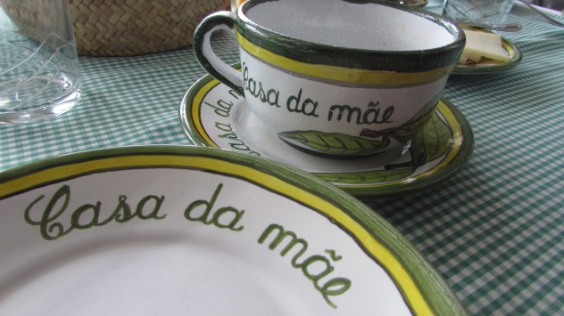
While we’re delighted at the prospect of spending another night at our favourite Casa de Mae in Salir, there is no comfortable overnight accommodation in Ameixial. The only option is to spend the night at a hostel (for which you have to pick up the key from a local cafe). I’m not keen. Our memorable night on the floor of the community centre in Marmelete demonstrated three things:
a) I do not like sleeping in shared accommodation
b) sleep is impossible in shared accommodation
c) getting no sleep in shared accommodation results in a miserable day’s hiking.

Clearly, we shall have to review the situation but it’s looking like we will be tackling a three-day circular walk in the Serra do Caldeirão to avoid this particular issue.
Setting off
Harri is well-versed in the logistics of tackling long-distance trails in short bursts (our walking of the Cambrian Way springs to mind). This time around, he thought it best if we parked at Loulé station (which is nowhere near the city) and caught a train to Faro. We could then walk back to the station the following morning on the lower section of the Via Algarviana‘s Loulé-Salir link route.

The camino starts outside Faro’s main cathedral which meant a short detour from the railway station (and back again). I dodged the numerous tour groups and posed for a quick photograph on the steps.
Then we were off, passing the last official blue and yellow waymark we would see until our arrival in Loulé.
The first few hours were easy walking by anyone’s standards: there wasn’t a bump in the road. The landscape in this part of the Algarve is very different to where we live in Armação de Pera. Near us, it’s impossible to walk any distance without encountering an incline. Being Welsh, we’d certainly struggle to live somewhere as flat as Faro … a flat landscape just feels unnatural.
The first part of the route follows the popular Parque Ribeirinho de Faro, a public space adjacent to the Ria Formosa. From here, there are great views of Faro airport, with planes taking off and landing regularly. On a Saturday morning, the various trails were bustling with walkers, cyclists and runners, plus an extrovert body-builder type whose blasting music rather ruined the peacefulness of the surroundings.
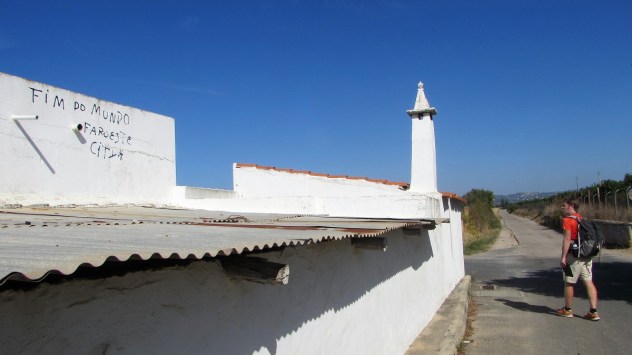
We were still in Faro an hour and a half later when we stopped for elevenses on the steps of an apartment block. Not for much longer though. Soon after setting off again, we passed a whitewashed property onto which someone had helpfully painted ‘Fim do mundo, Faro Este‘ (end of the world, western Faro). These pilgrims were finally on their way.
It might have been the heat – or perhaps we’re just out of practice – but already Harri and I were starting to feel weary. The landscape was now properly rural and the line of hills that had looked so distant in Faro were looming ever closer.
And then the climbing started …
Santa Bárbara de Nexe
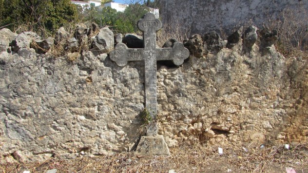
We approached Santa Bárbara de Nexe from the Camino da Falfofa, where a large stone cross is set into an old wall.

It was around 1pm and we’d been looking forward to passing through the village for two reasons. First, we’d actually considered buying here at one point and were curious to see if it was as nice ‘in person’ as it looked on the photographs. Santa Bárbara is close to Faro (for the airport, culture and islands) and two years ago the sky-high prices of the coast had yet to reach this pretty whitewashed village. Secondly, we were in dire need of a cold beer and Santa Bárbara boasts several bars. We were so thirsty, in fact, that we ended up ordering beers and Calippos. For many years, Santa Bárbara was the unlikely location for Eddie’s Bar, a venue owned by Iron Maiden bassist Steve Harris and dedicated to the heavy metal band. Sadly, the bar closed in 2017.

Regrettably, I have no photographs of our walk after we left Santa Bárbara (I somehow lost half my pics during the uploading process). It’s a shame because some of the best views of the walk were those between Santa Bárbara and Loulé, not least because we were on the slopes of the Serra de Monte Figo looking down towards the coastal strip.
The climb after the beer
Those pilgrims must have been far fitter than me, for the afternoon’s walking was tough going. We passed a beautiful old quinta on the outskirts of Santa Bárbara and joined a historic walled lane, climbing ever higher.
As the trail underfoot became rutted and uneven, I found myself stopping every few minutes for a breather. Santa Bárbara already looked distant, its properties a cluster of white blobs on the slopes far below. Above, several properties enjoyed lofty positions and impossible access. I began to worry about our water situation. Harri had only brought two 500ml bottles and I was carrying just a one-litre container plus the small 250ml bottle I use for running. In the summer, we’d carried far more liquids, including tonic water and shandy, but we simply hadn’t anticipated such high temperatures in mid-October (or such tough terrain).

At the top of the track, we collapsed on a drystone wall. To our right, a level tarmac single track was visible, providing vehicle access for the houses. The near-vertical track was only for the pilgrims then.
On the far side of the ridge, the views of the barrocal were equally impressive, although the identity of a large expanse of water remains a mystery even now. According to the mapping, there shouldn’t be a reservoir in that location!!
I’d heaved a sigh of relief when Harri announced we’d probably done most of the climbing; however, unusually he was wrong. With very little water left in our bottles and less than 5km to walk to Loulé, we found ourselves climbing steeply again, this time on a narrow, uneven footpath high above a wooded valley.
Waymarking
Perhaps I should mention here the Central Camino de Santiago is not yet officially waymarked. That said, there are large yellow arrows painted at regular intervals along the trail and at junctions. We actually found the unofficial markers better than we’d expected. The only time we nearly went astray was on the long descent into Loulé – the trick is to veer left each time you encounter a junction of footpaths.

Arriving in Loulé
We’d toyed with the idea of going out for a meal in Loulé to celebrate Harri’s birthday, but we were just too tired. It was not even five and I could have fallen asleep over my beer. We’d booked into the Loulé Jardim Hotel which is just fabulous so we raised our weary bodies one last time to wander off to Pingo Doce and grab some cooked chicken, nibbles and wine to eat in our room (finding out too late that Uber Eats can be ordered at reception).

The first day of our pilgrimage had been pretty hard going. We always say it takes four days to get into the swing of long-distance hiking, to get into the flow of things and get used to being on your feet all day.
Hopefully it won’t be too long before we’re able to resume our pilgrimage.
Our route
If anyone is interested in walking the Central Camino de Santiago, here’s a link to the mapping for the Faro to Loulé section.
Discover more from tracyburton.co.uk
Subscribe to get the latest posts sent to your email.


Denise Gray
Gosh, another fabulous walk you are doing